Pago
Pago (pronounced Pango Pango),
American
Samoa
November 4, 2011
After 4 days at sea we reach
Samoa ~
The Samoan island chain lies in
the center of the South Pacific, about 2,300 miles southwest of Honolulu. Since 1899, it has been divided into Western
and Eastern ~ or American Samoa. The
islands comprise the only American Territory in the southern hemisphere.
Useful words Samoan words used here are ~
Hello …………Talofa (Tah-low-fah)
Good Bye ……Tofa
(Tow-fah)
Thank You …..Fa’afafine (fah-fee-tie)
Our Tour Provider is: Oceania Travel ~
Contact: Sulu Malifa ~
mailto:oceaniatravel@ipasifika.net
Duration of Tour : 6 hrs ~
Starts at 11 AM from the wharf.
Includes Lunch (No swimming)
This tour is in a Samoan style wood bus.
***Just a short note about these Samoan Style wood buses ~
For the safety of you bum . . .
*Bring a folded beach towel from your cabin to sit on ~
you will thank me, afterward!
:-)
DOWNTOWN & EASTSIDE
Enjoy
a city tour of downtown Pago Pago combined with a scenic drive to the east end
of Tutuila. Drive along the islands rugged east coast, mountains, coral reefs
and the deep blue Pacific ocean all around you on this drive to the end of the
road at CAPE TULA the eastern most tip of the island. As we wind past one headland after another,
glimpse everyday village life as
people
go about their business of planting, harvesting, and fishing, kids would play
under the breadfruit trees near their homes..
HIGHLIGHTS.
a. Leave
wharf area and turn right towards Downtown
b. drive
passed Post Office building, Fono (legislative) building, court bouse, museum,
colorful farmers produce market, variety of fruits vegetable, local fare,
island handicrafts.
c. take
a look at Sadie’s Inn (formerly Sadies boarding house
d. Pago
Pago Bay & Curving harbor – is the finest in the south pacific.
e. Harbour
Curve – site that offers wonderful views over Pago Pago bay, harbour and town
at a distant.
Tour continues cruising around pago harbor curve,
ascending to shoulder of “Rainkamer Mountain” with panoramic view of Avaio
beach and Auasi shoreline.
f. drive
passed the one remaining fish cannery STARKIST. The two fish canneries were the
two main employers on the island have been the mainstay of the economy for many
years, until late last year when one closed down leaving only one in operation.
g. Aunu’u
jetty – offshore island 2 miles from main island – boat jetty.
h. Tisa’s
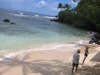
barefoot bar – a quaint local bar set on a long stretch of white sandy beach.
i. Cape
Tula – easternmost tip of the island – this area is home to the island’s oldest
settlement and gorgeous surfing beaches, tour turns around from Tula.
*guy carrying squid *
j. enjoy
this scenic drive along the coast. This
side of the island is mountainous, lush green rich in tropical rainforest and
vegetation with dense foliage. The scenery is colorful its green and
match by the deep blue of the
ocean and the roaring sea. People of
these outer districts live a simple life of planting and fishing, happy in
their surroundings, you will see them set out in their daily routine of
working, playing and resting underneath the cool of trees or in their open “fales”
WESTSIDE
Tour
CONTINUES passed downtown and will take you passed some of the most beautiful scenery
on the island, The land is more flat on this side and population more dense.
Neat picturesque villages, with clean
well kept gardens, tropical plants with flowers blooming everywhere. The island is volcanic with volcanic
formations surrounded by coral reefs, palm fringed lagoons, turquoise waters
and unusual rock formations. Our road will wind in and out of small bays with
sandy beaches, climb a spectacular panoramic ridge and wind through pretty
seaside villages that reveal the tropical beauty of the island and the
lifestyle of its people.
Highlights
a. Tour
leaves town area and head westward.
b. Rainmaker
Mountain – overlooking majestic Pago Pago Harbour and Sadies Hotel a landmark
location formerly Rainmaker Hotel
c.
“Palolo” villages of Faganeanea & Nuuuli – “Palolo” a worm like fish rise
once a year, which produces a Samoan caviar
d. Rock
formations – Flower Pot Rock set in a turquoise lagoon.
e. continue
westwards to Communication Centre and Industrial Park
f. Old
Mormon Valley – American Samoa Community college is now housed in the buildings
and complex once owned by the Mormon Church, in part of the old Mormon Valley –
a beautiful area of lush green vegetation and rainforest
g. Leone
Village – Congregational Christina Church and chiefly Samoan Fale (house) Leone
formerly the island’s capital, this picturesque village is known as the “cradle
of Christianity” because it is here that John Williams, the islands first
missionary, landed in 1832. Visit the islands oldest church, also a typical
traditional chiefly Samoan fale used during village (fono) meetings and family
gatherings.
h. Vailoatai
village – enjoy expansive views of the distant horizon and deep blue ocean as
we drive passed this pretty seaside village with its neat fales & clean surroundings.
i. drive
passed clean beautiful villages, beautiful flowers & well tended gardens,
this side noted for its pristine white sand beaches.
j. last
stop Vaitogi village, visit the location of the old Samoan legend of the turtle
& shark (mother & daughter who turned into a turtle & shark)
villagers still sound the “chant”
k. tour
turns around from here.
l. drive
passed Tafuna International Airport.
m. Lions
Park area designated for sporting activities and family picnics.
n. Return
Drive along the same road towards town.
o. stop
at Alaimantu Bed and Breakfast for lunch
A
private home with gorgeous yard and a bridge over stepped swimming pool that
served us the most excellent food, drinks and tropical fruit for lunch.
Email ~ toologatupoi@yahoo.com
p. before returning to your ship a two minute walk away.


No comments:
Post a Comment